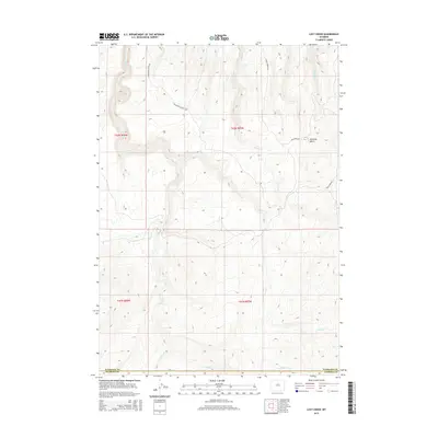
2015 Map of Lost Creek
USGS Topo · Published 2015About this map
Kennedy Basin occupies the northeastern corner of this remote high-plains landscape where the borders of Washakie and Natrona Counties meet. The area is defined by a dendritic network of seasonal drainages, most notably Lost Cr and its counterpart, Little Lost Creek, which carve through the elevations alongside Deep Cr and Little Deep Creek. Human imprint is sparse, concentrated primarily on a few ranching or access routes such as Mahagony Butte Rd and Cherry Creek Rd. The drainage patterns and topographic contours reveal a transition between high basins and the breaks of the Wyoming interior, providing a clear record of the watershed and land partitions used by the Bureau of Land Management and local ranchers during the early 21st century.
Find a feature on this map
15 named features on this map. Tap any name to fly to it.
Don’t see what you’re looking for? This feature index may not catch every label — zoom into the map to look around manually.
Map Details
Editions of this 2015 Lost Creek Map
This is the sole edition of this map. No revisions or reprints were ever made.
Other maps of this area

1952 · Grave Spring
USGS Topo · 1:24,000

1952 · Sioux Pass
USGS Topo · 1:24,000

1952 · Badwater NE
USGS Topo · 1:24,000

1955 · Arminto
USGS Topo · 1:250,000

1958 · Arminto
USGS Topo · 1:250,000

1962 · Arminto
USGS Topo · 1:250,000

1967 · Mahogany Butte
USGS Topo · 1:24,000
1967 · Cornell Gulch
USGS Topo · 1:24,000

1967 · Horse Butte
USGS Topo · 1:24,000
1967 · Lightning Ridge
USGS Topo · 1:24,000