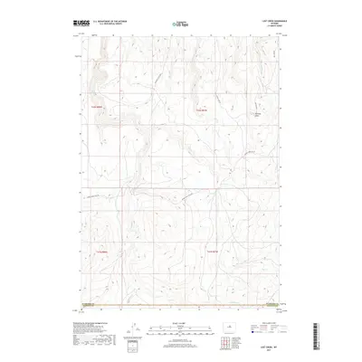
2017 Map of Lost Creek
USGS Topo · Published 2017About this map
Kennedy Basin sits as a prominent geological feature in this high-altitude drainage divide near the Washakie and Natrona county border. The landscape is defined by its intermittent watercourses, including the eponymous Lost Creek and Little Lost Creek, which channel seasonal runoff through the high plains. The transport network reflects the area's ranching and livestock heritage, evidenced by the Cherry Creek Stock Drive and high-ridge access routes like Mahagony Butte Road. These thoroughfares, alongside Cherry Creek Road and Box Elder Road, provide the primary infrastructure through this isolated terrain where public land and private holdings intermingle. The surveyor's data captures a high-desert environment where water remains the most significant variable, from the drainage of Deep Creek to the smaller Little Deep Creek.
Find a feature on this map
17 named features on this map. Tap any name to fly to it.
Don’t see what you’re looking for? This feature index may not catch every label — zoom into the map to look around manually.
Map Details
Editions of this 2017 Lost Creek Map
This is the sole edition of this map. No revisions or reprints were ever made.
Other maps of this area

1952 · Grave Spring
USGS Topo · 1:24,000

1952 · Sioux Pass
USGS Topo · 1:24,000

1952 · Badwater NE
USGS Topo · 1:24,000

1955 · Arminto
USGS Topo · 1:250,000

1958 · Arminto
USGS Topo · 1:250,000

1962 · Arminto
USGS Topo · 1:250,000

1967 · Mahogany Butte
USGS Topo · 1:24,000
1967 · Cornell Gulch
USGS Topo · 1:24,000

1967 · Horse Butte
USGS Topo · 1:24,000
1967 · Lightning Ridge
USGS Topo · 1:24,000