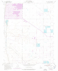
1954 Map of Lost Hills NE
USGS Topo · Published 1977About this map
Semitropic Ridge anchors this landscape in the San Joaquin Valley, where the topography was shaped by both natural drainage and industrial water management. This area, updated with 1970s revisions, highlights an extensive network of waterfowl management areas and private hunting grounds. Multiple clubs are clearly delineated, including the Donald Duck Gun Club, Superior Gun Club, and Los Patos Gun Club, which relied on the local system of ditches and the Goose Lake Canal. The human footprint is defined by agricultural and industrial infrastructure, such as Dairy Avenue, the Cole Ranch, and scattered evidence of petroleum exploration including Oil Well (Aban'd) markers. A landing strip and various water storage features like the Reservoir indicate a rural economy focused on large-scale land management and seasonal sporting activities.
Find a feature on this map
20 named features on this map. Tap any name to fly to it.
Don’t see what you’re looking for? This feature index may not catch every label — zoom into the map to look around manually.
Map Details
Editions of this 1954 Lost Hills NE Map
2 editions found
Other maps of this area

1914 · Lost Hills
USGS Topo · 1:125,000

1927 · Semitropic
USGS Topo · 1:31,680

1929 · Hacienda Ranch
USGS Topo · 1:31,680

1929 · Allensworth
USGS Topo · 1:31,680

1930 · Leonards
USGS Topo · 1:31,680

1930 · Hamlin School
USGS Topo · 1:31,680

1930 · Miramonte Ranch
USGS Topo · 1:31,680

1931 · Goose Lake
USGS Topo · 1:31,680

1932 · West of Goose Lake
USGS Topo · 1:31,680

1932 · Reynolds Ranch
USGS Topo · 1:31,680