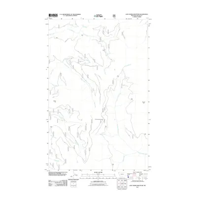
2011 Map of Lost Horse Mountain
USGS Topo · Published 2011About this map
Lost Horse Mountain and its surrounding drainages in Lincoln County are defined by a complex network of US Forest Service transportation routes. This 2011 survey by the U.S. Geological Survey and U.S. Forest Service documents the management of these public lands through a hierarchy of roads, including Natl Forest Develop Road 6718 RD and Natl Forest Develop Road 6062 RD. The landscape is a hydrology-dense area where numerous tributaries like Yodlin Creek, Beaver Creek, and Fowler Creek descend from high ridges such as Beetle Hill. A significant water feature, Turner Falls, is situated along Turner Creek, marking a notable elevation drop in the northern section of the map. This era of mapping emphasizes the intersection of natural topography and the forest development infrastructure necessary for land oversight in Montana's remote interior.
Find a feature on this map
19 named features on this map. Tap any name to fly to it.
Don’t see what you’re looking for? This feature index may not catch every label — zoom into the map to look around manually.
Map Details
Editions of this 2011 Lost Horse Mountain Map
This is the sole edition of this map. No revisions or reprints were ever made.
Other maps of this area

1957 · Kalispell
USGS Topo · 1:250,000

1960 · Kalispell
USGS Topo · 1:250,000

1961 · Kalispell
USGS Topo · 1:250,000

1963 · Yaak
USGS Topo · 1:24,000

1963 · Robinson Mountain
USGS Topo · 1:24,000

1963 · Pink Mountain
USGS Topo · 1:24,000

1963 · Boulder Lakes
USGS Topo · 1:24,000

1963 · Bonnet Top
USGS Topo · 1:24,000

1963 · Mount Henry
USGS Topo · 1:24,000
1963 · Flatiron Mountain
USGS Topo · 1:24,000