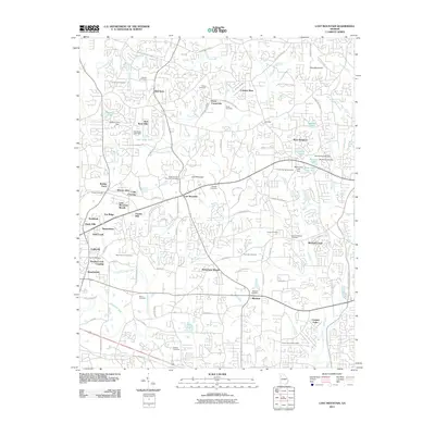
2011 Map of Lost Mountain
USGS Topo · Published 2011About this map
Lost Mountain serves as a prominent landmark in this corner of Cobb County, where residential growth increasingly defined the landscape by the early 21st century. The map reveals an intricate network of subdivisions and neighborhoods such as McEachern Woods, West Hampton, and California, which are interspersed with older family-named landmarks and rural burial grounds. Genealogists will find a wealth of specific local history in the numerous cemeteries preserved amidst the modern development, including Shipp-Old Lost Mountain Cemetery, Echols Cemetery, and Post Oak Cemetery. The drainage patterns of Allatoona Creek and Powder Springs Creek continue to shape the terrain, even as traditional farming areas like Brooks Farm transitioned into new residential pockets. This survey captures a moment of modern suburbanization while maintaining the cartographic record of foundational local sites like Davis Crossroads and the community of Macland.
Find a feature on this map
107 named features on this map. Tap any name to fly to it.
Don’t see what you’re looking for? This feature index may not catch every label — zoom into the map to look around manually.
Map Details
Editions of this 2011 Lost Mountain Map
This is the sole edition of this map. No revisions or reprints were ever made.
Other maps of this area

1890 · Cartersville
USGS Topo · 1:125,000

1891 · Marietta
USGS Topo · 1:125,000

1891 · Cartersville
USGS Topo · 1:125,000

1895 · Marietta
USGS Topo · 1:125,000

1896 · Cartersville
USGS Topo · 1:125,000

1897 · Marietta
USGS Topo · 1:125,000

1901 · Marietta
USGS Topo · 1:125,000

1906 · Stilesboro
USGS Topo · 1:62,500

1907 · Acworth
USGS Topo · 1:62,500

1908 · Stilesboro
USGS Topo · 1:62,500