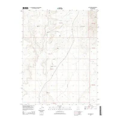
2014 Map of Lost Spring
USGS Topo · Published 2014About this map
The desert settlement of Ticaboo stands as a focal point in this remote corner of Garfield County, positioned along the corridor of Ut-276. The landscape is defined by the dramatic transitions of the Henry Mountains, culminating in the high elevation of Mt Ellsworth to the northeast. Water management in this arid environment is evidenced by the Lost Spring Reservoir and the drainage patterns of Lost Spring Wash and Hansen Cr. To the south, the expansive Cane Spring Desert stretches across the quadrangle, while prominent geological features like Shootaring Point and Ant Knolls provide critical navigational landmarks. Local transit is captured through rural routes such as Shootaring Rd and Spring Desert Rd, which connect the isolated outposts of the plateau to the surrounding canyons and washes.
Find a feature on this map
26 named features on this map. Tap any name to fly to it.
Don’t see what you’re looking for? This feature index may not catch every label — zoom into the map to look around manually.
Map Details
Editions of this 2014 Lost Spring Map
This is the sole edition of this map. No revisions or reprints were ever made.
Other maps of this area

1886 · Henry Mountains
USGS Topo · 1:250,000

1892 · Henry Mountains
USGS Topo · 1:250,000

1952 · Mt Pennell 1 SW
USGS Topo · 1:24,000

1952 · Mt Hillers
USGS Topo · 1:62,500

1952 · Mt Pennell 1 SE
USGS Topo · 1:24,000

1953 · Mt Pennell
USGS Topo · 1:62,500

1953 · Mt Pennell 2 SE
USGS Topo · 1:24,000

1953 · Mt Pennell 4 NE
USGS Topo · 1:24,000

1953 · Mt. Ellsworth
USGS Topo · 1:62,500

1953 · Hall Mesa
USGS Topo · 1:62,500