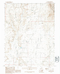
1987 Map of Lost Spring
USGS Topo · Published 1988About this map
Ticaboo stands as a primary point of human activity in this arid Garfield County landscape, complete with an Athletic Field, a Trailer Park, and nearby Sewage Disposal Ponds. The map reveals a reliance on water management in a desert environment, evidenced by the Lost Spring Reservoir, Highway Reservoir, and Cane Spring Well. This 1980s-era topography illustrates the intersection of infrastructure and geological isolation, where mining activity is noted by a Mine and Adit near the northern boundary. The terrain is dominated by high-relief landforms such as Shootaring Point and the Little Rockies, part of the larger Henry Mountains system. Drainage patterns are defined by several watercourses, including Shitamaring Creek, Hansen Creek, and Smith Fork, which carve through the Cane Spring Desert.
Find a feature on this map
22 named features on this map. Tap any name to fly to it.
Don’t see what you’re looking for? This feature index may not catch every label — zoom into the map to look around manually.
Map Details
Editions of this 1987 Lost Spring Map
This is the sole edition of this map. No revisions or reprints were ever made.
Other maps of this area

1886 · Henry Mountains
USGS Topo · 1:250,000

1892 · Henry Mountains
USGS Topo · 1:250,000

1952 · Mt Pennell 1 SW
USGS Topo · 1:24,000

1952 · Mt Hillers
USGS Topo · 1:62,500

1952 · Mt Pennell 1 SE
USGS Topo · 1:24,000

1953 · Mt Pennell
USGS Topo · 1:62,500

1953 · Mt Pennell 2 SE
USGS Topo · 1:24,000

1953 · Mt Pennell 4 NE
USGS Topo · 1:24,000

1953 · Mt. Ellsworth
USGS Topo · 1:62,500

1953 · Hall Mesa
USGS Topo · 1:62,500