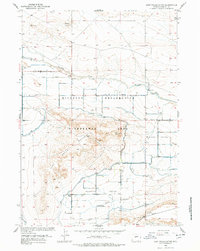
1958 Map of Lost Wells Butte
USGS Topo · Published 1978About this map
The Riverton Reclamation Withdrawal Area dominates this mid-century landscape in Fremont County, where irrigation infrastructure transformed the high plains of the Missouri River Basin. The map details the complex water-management systems essential to this agricultural expansion, featuring the Pilot Canal, Lost Wells Lateral, and Ocean Drain. These engineered waterways cut through the natural topography defined by Lost Wells Butte and the surrounding Missouri Valley. Local social centers are anchored by the Union Church and the Paradise Valley Community House, serving the rural residents settled along Missouri Valley Road and Burma Road. This survey documents a critical era of federal reclamation projects, illustrating how desert land was reclaimed for homesteading and farming through systematic irrigation and drainage.
Find a feature on this map
19 named features on this map. Tap any name to fly to it.
Don’t see what you’re looking for? This feature index may not catch every label — zoom into the map to look around manually.
Map Details
Editions of this 1958 Lost Wells Butte Map
3 editions found
Other maps of this area

1950 · Riverton East
USGS Topo · 1:24,000

1950 · Harris Bridge
USGS Topo · 1:24,000

1950 · Mexican Pass SW
USGS Topo · 1:24,000

1950 · Ocean Lake
USGS Topo · 1:24,000

1951 · Mexican Pass SE
USGS Topo · 1:24,000

1951 · Pavillion SE
USGS Topo · 1:24,000

1951 · Riverton West
USGS Topo · 1:24,000

1952 · Riverton NE
USGS Topo · 1:24,000

1952 · Lost Wells Butte
USGS Topo · 1:24,000

1955 · Thermopolis
USGS Topo · 1:250,000