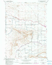
1958 Map of Lost Wells Butte
USGS Topo · Published 1991About this map
Lost Wells Butte anchors this landscape in the Fremont County region, revealing the complex water management system central to the area's development. The map details the Riverton Reclamation Withdrawal Area, where a network of man-made waterways like the Pilot Canal, Lost Wells Lateral, and Pavillion Drain work to transform the arid terrain. This reclamation infrastructure defines the local geography, illustrating the transition from natural drainage to a managed agricultural environment.
Find a feature on this map
18 named features on this map. Tap any name to fly to it.
Don’t see what you’re looking for? This feature index may not catch every label — zoom into the map to look around manually.
Map Details
Editions of this 1958 Lost Wells Butte Map
3 editions found
Other maps of this area

1950 · Riverton East
USGS Topo · 1:24,000

1950 · Harris Bridge
USGS Topo · 1:24,000

1950 · Mexican Pass SW
USGS Topo · 1:24,000

1950 · Ocean Lake
USGS Topo · 1:24,000

1951 · Mexican Pass SE
USGS Topo · 1:24,000

1951 · Pavillion SE
USGS Topo · 1:24,000

1951 · Riverton West
USGS Topo · 1:24,000

1952 · Riverton NE
USGS Topo · 1:24,000

1952 · Lost Wells Butte
USGS Topo · 1:24,000

1955 · Thermopolis
USGS Topo · 1:250,000