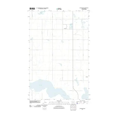
2011 Map of Lostwood
USGS Topo · Published 2011About this map
White Lake dominates the southern landscape of this Mountrail County region, its irregular shoreline providing a significant hydrological anchor for the surrounding prairie. To the north, the small settlement of Lostwood serves as a central point in a grid of section-line roads, including 81st Ave NW and 73rd St NW. The terrain is characterized by the glacial potholes typical of the Missouri Coteau, where features like Kittelson Slough and numerous unnamed smaller wetlands indicate a landscape shaped by internal drainage. In the eastern portion of the quadrangle, the location of Wassaic marks another point of settlement within this agricultural and waterfowl-rich environment. The 2011 survey by the U.S. Geological Survey reflects the enduring rural character of the area, defined by its sparse population and heavy reliance on the natural water bodies that dot the high plains.
Find a feature on this map
19 named features on this map. Tap any name to fly to it.
Don’t see what you’re looking for? This feature index may not catch every label — zoom into the map to look around manually.
Map Details
Editions of this 2011 Lostwood Map
This is the sole edition of this map. No revisions or reprints were ever made.
Other maps of this area

1953 · Williston
USGS Topo · 1:250,000

1957 · Williston
USGS Topo · 1:250,000

1969 · Stanley
USGS Topo · 1:24,000

1969 · Stanley SE
USGS Topo · 1:24,000

1974 · Lostwood Lakes
USGS Topo · 1:24,000

1978 · Westby Lake
USGS Topo · 1:24,000
1978 · Lunds Valley
USGS Topo · 1:24,000

1981 · Ross
USGS Topo · 1:24,000

1981 · Stanley SE
USGS Topo · 1:24,000

1981 · Lostwood
USGS Topo · 1:24,000