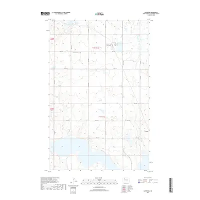
2017 Map of Lostwood
USGS Topo · Published 2017About this map
White Lake dominates the southern landscape of this Mountrail County survey, anchor to a glaciated terrain defined by numerous small depressions and sloughs. The rural character of the region is evident in the sparse settlement pattern, where the namesake community of Lostwood serves as a local landmark. A notable concentration of community history is found at the Lostwood Cem and the German Mennonite Cem, providing valuable physical markers for genealogists and local historians tracking the early families of the central North Dakota plains. The map reveals a strictly regulated grid of section lines and gravel roads, including 81st Ave NW and 73rd St NW, which dictate the movement across this agricultural and wetland mosaic. To the north, the Kittelson Slough and various unnamed water bodies reflect the hydrologic complexity of the Prairie Pothole Region.
Find a feature on this map
25 named features on this map. Tap any name to fly to it.
Don’t see what you’re looking for? This feature index may not catch every label — zoom into the map to look around manually.
Map Details
Editions of this 2017 Lostwood Map
This is the sole edition of this map. No revisions or reprints were ever made.
Other maps of this area

1953 · Williston
USGS Topo · 1:250,000

1957 · Williston
USGS Topo · 1:250,000

1969 · Stanley
USGS Topo · 1:24,000

1969 · Stanley SE
USGS Topo · 1:24,000

1974 · Lostwood Lakes
USGS Topo · 1:24,000

1978 · Westby Lake
USGS Topo · 1:24,000
1978 · Lunds Valley
USGS Topo · 1:24,000

1981 · Ross
USGS Topo · 1:24,000

1981 · Stanley SE
USGS Topo · 1:24,000

1981 · Lostwood
USGS Topo · 1:24,000