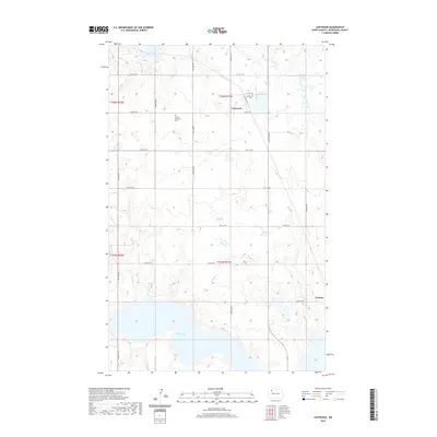
2020 Map of Lostwood
USGS Topo · Published 2020About this map
Lostwood sits amidst the characteristic prairie pothole region of North Dakota, where the landscape is defined by countless small wetlands and the expansive White Lake. This 2020 topographic record highlights the sparse, rural settlement pattern of Mountrail County, anchored by small community centers and sites of local heritage. Genealogists can identify significant burial sites in the area, specifically the Lostwood Cem near the townsite and the German Mennonite Cem to the west. The map also captures Wassaic on the eastern edge of the quadrangle. The grid of section roads, including 73rd St NW and 70th St NW, provides a structured view of how land is managed and accessed in this high-plains environment.
Find a feature on this map
17 named features on this map. Tap any name to fly to it.
Don’t see what you’re looking for? This feature index may not catch every label — zoom into the map to look around manually.
Map Details
Editions of this 2020 Lostwood Map
This is the sole edition of this map. No revisions or reprints were ever made.
Other maps of this area

1953 · Williston
USGS Topo · 1:250,000

1957 · Williston
USGS Topo · 1:250,000

1969 · Stanley
USGS Topo · 1:24,000

1969 · Stanley SE
USGS Topo · 1:24,000

1974 · Lostwood Lakes
USGS Topo · 1:24,000

1978 · Westby Lake
USGS Topo · 1:24,000
1978 · Lunds Valley
USGS Topo · 1:24,000

1981 · Ross
USGS Topo · 1:24,000

1981 · Stanley SE
USGS Topo · 1:24,000

1981 · Lostwood
USGS Topo · 1:24,000