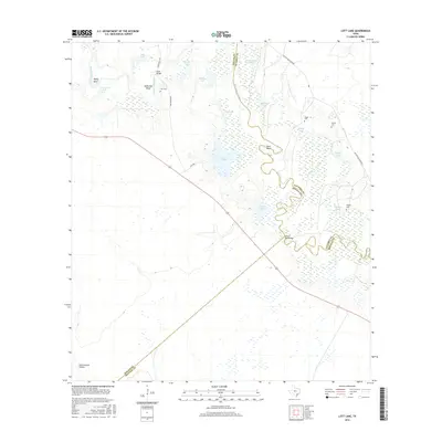
2016 Map of Lott Lake
USGS Topo · Published 2016About this map
The San Antonio River carves a meandering path across this landscape, forming complex oxbows and bends such as Hovey Bend, McKinney Bend, and Burn Bend. This riverine environment is defined by an extensive network of wetlands and small lakes, including Lott Lake, Melinda Lake, and Redding Lake. The map reveals the intersection of Goliad, Victoria, and Refugio counties, where transportation is limited to rural routes like Duke Ranch Rd and San Antonio River Rd. For genealogists, the presence of family-named landmarks provides significant value, specifically the Lott Cem, Fagan Cem, Terrell Cem, and Sample Cem. These small burial grounds, alongside crossings like Duke Bridge and Simms Footbridge, suggest a long history of local landownership and rural residency along the fertile river bottomlands.
Find a feature on this map
31 named features on this map. Tap any name to fly to it.
Don’t see what you’re looking for? This feature index may not catch every label — zoom into the map to look around manually.
Map Details
Editions of this 2016 Lott Lake Map
This is the sole edition of this map. No revisions or reprints were ever made.
Other maps of this area

1953 · Beeville
USGS Topo · 1:250,000

1954 · Vidaurri
USGS Topo · 1:62,500

1954 · Refugio
USGS Topo · 1:62,500

1956 · Beeville
USGS Topo · 1:250,000

1960 · Beeville
USGS Topo · 1:250,000

1962 · Live Oak Lake
USGS Topo · 1:24,000

1962 · Fannin
USGS Topo · 1:24,000

1962 · Lott Lake
USGS Topo · 1:24,000

1962 · McFaddin
USGS Topo · 1:24,000

1962 · Hensley Lake
USGS Topo · 1:24,000