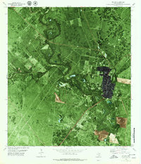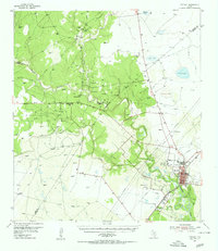
1954 Map of Refugio
USGS Topo · Published 1956About this map
Refugio stands at the heart of this coastal prairie landscape, its grid defined by the convergence of the Missouri Pacific railroad and the winding Mission River. The local economy of the mid-1950s is clearly etched into the terrain, dominated by extensive energy infrastructure such as the Refugio Oil Field and the Melon Creek Oil Field. Scattered throughout the rural stretches are small community anchors like Blanconia, which features the Blanconia Sch and nearby McQuill Cem, illustrating the distributed settlement patterns common before more centralized development took over.
Find a feature on this map
40 named features on this map. Tap any name to fly to it.
Don’t see what you’re looking for? This feature index may not catch every label — zoom into the map to look around manually.
Map Details
Editions of this 1954 Refugio Map
This is the sole edition of this map. No revisions or reprints were ever made.
Historical Maps of Refugio Through Time
7 maps found