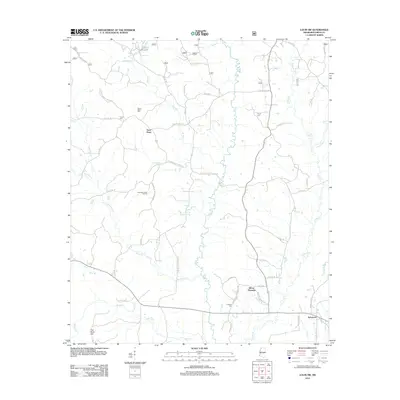
2012 Map of Louin SW
USGS Topo · Published 2012About this map
The Leaf River meanders through the heart of this Smith County landscape, defining a network of tributaries including Ichusa Cr and Shongelo Cr. The 2012 topography reveals a mix of timberland and industry, most notably the Shongelo Creek Oil Field situated in the western portion of the quadrangle. Small settlements such as Sylvarena and Mount Pleasant anchor the road system, which is a combination of county routes and forest service roads like US Forest Service Road 533.
Find a feature on this map
59 named features on this map. Tap any name to fly to it.
Don’t see what you’re looking for? This feature index may not catch every label — zoom into the map to look around manually.
Map Details
Editions of this 2012 Louin SW Map
This is the sole edition of this map. No revisions or reprints were ever made.
Other maps of this area

1953 · Hattiesburg
USGS Topo · 1:250,000

1953 · Meridian
USGS Topo · 1:250,000

1957 · Meridian
USGS Topo · 1:250,000

1958 · Hattiesburg
USGS Topo · 1:250,000

1965 · Meridian
USGS Topo · 1:250,000

1968 · Clear Springs
USGS Topo · 1:24,000

1968 · Pineville
USGS Topo · 1:24,000
1968 · Homewood
USGS Topo · 1:24,000

1968 · Raleigh
USGS Topo · 1:24,000

1968 · Louin
USGS Topo · 1:24,000