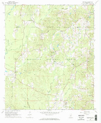
1968 Map of Homewood
USGS Topo · Published 1970About this map
The Bienville National Forest dominates this section of the Mississippi pine belt, where the boundary between Scott and Smith counties cuts through a landscape of creek bottoms and timbered ridges. Small rural communities like Homewood, Lorena, and Burns serve as anchors for a network of country churches and family cemeteries, including Luther Chapel Cem and Black Cem. The presence of Bentonite Pits near Yellow Creek indicates the importance of local clay mining to the mid-century economy, while a Gravel Pit near Barber Creek points to road-building activities in the late 1960s.
Find a feature on this map
42 named features on this map. Tap any name to fly to it.
Don’t see what you’re looking for? This feature index may not catch every label — zoom into the map to look around manually.
Map Details
Editions of this 1968 Homewood Map
2 editions found
Other maps of this area

1921 · Forest
USGS Topo · 1:48,000

1922 · Forest
USGS Topo · 1:62,500

1922 · Morton
USGS Topo · 1:48,000

1924 · Morton
USGS Topo · 1:62,500

1935 · White Oak
USGS Topo · 1:24,000

1950 · Forest
USGS Topo · 1:62,500

1951 · Morton
USGS Topo · 1:62,500

1952 · Forest
USGS Topo · 1:62,500

1953 · Meridian
USGS Topo · 1:250,000

1957 · Meridian
USGS Topo · 1:250,000