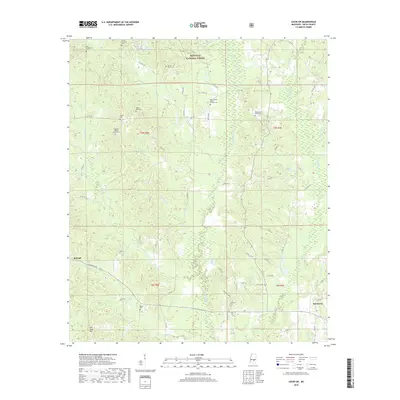
2018 Map of Louin SW
USGS Topo · Published 2018About this map
The Bienville National Forest dominates the northern reaches of this Smith County landscape, where the headwaters of the Leaf River and numerous small branches carve through the terrain. The eastern edge of Raleigh and the settlement of Sylvarena anchor the southern half of the map, connected by a network of rural routes including Sylvarena Ave and Co RD 501-2. This 2018 survey reveals a territory dense with genealogical markers, showcasing a significant concentration of family and community burial grounds such as Old Henderson Cem, Sylvan Grove Cem, and Royals and Webb Cem. The geography is defined by narrow drainage systems like Shongelo Cr and Tuhusa Cr, which weave around prominent elevations like Flat Rock Hill. Local spiritual life is centered at sites like High Hill Baptist Church Cem and Mount Nebo Baptist Church Cem, illustrating the dispersed settlement pattern typical of this Mississippi pine belt region.
Find a feature on this map
76 named features on this map. Tap any name to fly to it.
Don’t see what you’re looking for? This feature index may not catch every label — zoom into the map to look around manually.
Map Details
Editions of this 2018 Louin SW Map
This is the sole edition of this map. No revisions or reprints were ever made.
Other maps of this area

1953 · Hattiesburg
USGS Topo · 1:250,000

1953 · Meridian
USGS Topo · 1:250,000

1957 · Meridian
USGS Topo · 1:250,000

1958 · Hattiesburg
USGS Topo · 1:250,000

1965 · Meridian
USGS Topo · 1:250,000

1968 · Clear Springs
USGS Topo · 1:24,000

1968 · Pineville
USGS Topo · 1:24,000
1968 · Homewood
USGS Topo · 1:24,000

1968 · Raleigh
USGS Topo · 1:24,000

1968 · Louin
USGS Topo · 1:24,000