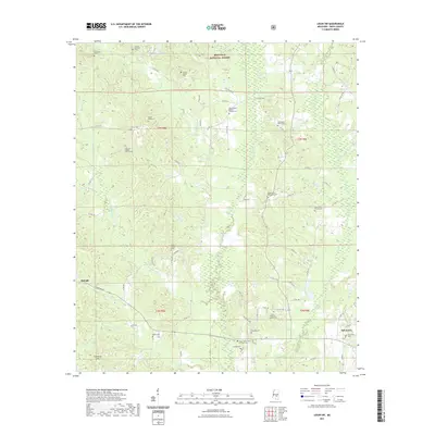
2021 Map of Louin SW
USGS Topo · Published 2021About this map
The Bienville National Forest dominates the northern reaches of this landscape, where the headwaters of the Leaf River and its numerous tributaries like Shongelo Cr and Pete Br carve through the terrain. The map captures a high density of small-scale community hubs in Smith County, particularly evident in the scattered rural churches and burial grounds that define the local geography. Significant sites include the Mount Nebo Baptist Church Cem and High Hill Baptist Church Cem, which serve as ancestral anchors for area families.
Find a feature on this map
124 named features on this map. Tap any name to fly to it.
Don’t see what you’re looking for? This feature index may not catch every label — zoom into the map to look around manually.
Map Details
Editions of this 2021 Louin SW Map
This is the sole edition of this map. No revisions or reprints were ever made.
Other maps of this area

1953 · Hattiesburg
USGS Topo · 1:250,000

1953 · Meridian
USGS Topo · 1:250,000

1957 · Meridian
USGS Topo · 1:250,000

1958 · Hattiesburg
USGS Topo · 1:250,000

1965 · Meridian
USGS Topo · 1:250,000

1968 · Clear Springs
USGS Topo · 1:24,000

1968 · Pineville
USGS Topo · 1:24,000
1968 · Homewood
USGS Topo · 1:24,000

1968 · Raleigh
USGS Topo · 1:24,000

1968 · Louin
USGS Topo · 1:24,000