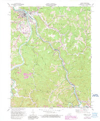
1971 Map of Louisa
USGS Topo · Published 1989About this map
Louisa and Fort Gay sit at the confluence of the Big Sandy River, Tug Fork, and Levisa Fork, marking the junction where Kentucky and West Virginia meet. This survey, updated in the early 1970s and late 1980s, reveals a landscape defined by its river crossings and the expansion of the extractive industry. The terrain south of the town centers is heavily marked by strip mines and reclaimed strip mine areas, particularly around Torchlight Hollow Creek and Stonecoal. The rural character of the river valleys is preserved through numerous family and community landmarks, such as Smith Chapel and Wilson Chapel, alongside small settlements like Walbridge and Saltpetre. In the eastern portion of the map, the hills around Bromley Ridge and Watts Ridge are dotted with isolated oil wells and gas infrastructure, illustrating the industrial footprint on the Appalachian highlands.
Find a feature on this map
105 named features on this map. Tap any name to fly to it.
Don’t see what you’re looking for? This feature index may not catch every label — zoom into the map to look around manually.
Map Details
Editions of this 1971 Louisa Map
4 editions found
Other maps of this area

1886 · Prestonsburg
USGS Topo · 1:125,000

1887 · Warfield
USGS Topo · 1:125,000

1891 · Warfield
USGS Topo · 1:125,000

1892 · Prestonsburg
USGS Topo · 1:125,000

1892 · Huntington
USGS Topo · 1:125,000

1898 · Huntington
USGS Topo · 1:125,000

1903 · Kenova
USGS Topo · 1:125,000

1904 · Kenova
USGS Topo · 1:125,000

1909 · Wayne
USGS Topo · 1:62,500

1910 · Naugatuck
USGS Topo · 1:48,000