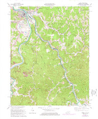
1971 Map of Louisa
USGS Topo · Published 1977About this map
The Big Sandy River and its primary forks define the borders and economy of this 1970s survey, where Louisa, Kentucky, sits at the confluence of the Levisa Fork and the Tug Fork. Across the water, Fort Gay, West Virginia, establishes the interstate character of the valley. Transport and industry are deeply etched into the hills, with the Norfolk and Western and Chesapeake and Ohio railroads following the riverbanks. Beyond the river hubs, the landscape is marked by extensive resource extraction, including Strip Mines and numerous Oil Wells.
Find a feature on this map
101 named features on this map. Tap any name to fly to it.
Don’t see what you’re looking for? This feature index may not catch every label — zoom into the map to look around manually.
Map Details
Editions of this 1971 Louisa Map
4 editions found
Other maps of this area

1886 · Prestonsburg
USGS Topo · 1:125,000

1887 · Warfield
USGS Topo · 1:125,000

1891 · Warfield
USGS Topo · 1:125,000

1892 · Prestonsburg
USGS Topo · 1:125,000

1892 · Huntington
USGS Topo · 1:125,000

1898 · Huntington
USGS Topo · 1:125,000

1903 · Kenova
USGS Topo · 1:125,000

1904 · Kenova
USGS Topo · 1:125,000

1909 · Wayne
USGS Topo · 1:62,500

1910 · Naugatuck
USGS Topo · 1:48,000