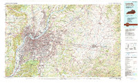
1986 Map of Louisville
USGS Topo · Published 1990About this map
The Ohio River serves as the central artery for this mid-1980s landscape, dividing the urban expanse of Louisville from its Indiana neighbors, Jeffersonville and New Albany. The city's growth is marked by the beltway of I-264 and the emerging path of I-265, while established landmarks like Cave Hill Cem and the Univ of Louisville anchor the historic core. Beyond the suburban developments of St Matthews and Jeffersontown, the terrain shifts toward the distinct topography of The Knobs and Muldraugh Hill. To the south, the massive Fort Knox Military Reservation dominates the landscape, while to the east, the map traces the rural character of Shelby County and Henry County. This survey documents a critical period of infrastructure expansion, showing the transition from a river-and-rail economy defined by the L & N RR to a modern interstate hub centered on Standiford Field.
Find a feature on this map
213 named features on this map. Tap any name to fly to it.
Don’t see what you’re looking for? This feature index may not catch every label — zoom into the map to look around manually.
Map Details
Editions of this 1986 Louisville Map
2 editions found
Other maps of this area

1905 · Harrodsburg
USGS Topo · 1:125,000

1905 · Prospect
USGS Topo · 1:62,500

1906 · Lockport
USGS Topo · 1:48,000

1907 · Louisville
USGS Topo · 1:62,500

1908 · Lockport
USGS Topo · 1:62,500

1909 · Kosmosdale
USGS Topo · 1:48,000

1912 · Prospect
USGS Topo · 1:62,500

1912 · Kosmosdale
USGS Topo · 1:62,500

1922 · Frankfort
USGS Topo · 1:48,000

1923 · Waddy
USGS Topo · 1:48,000