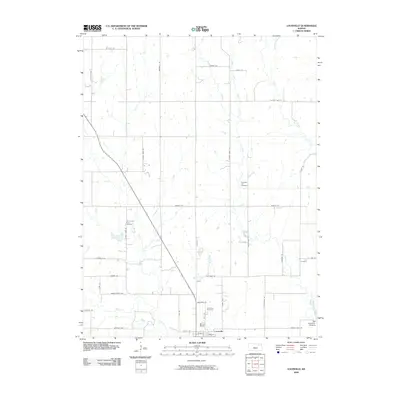
2009 Map of Louisville
USGS Topo · Published 2009About this map
Louisville stands at the heart of this landscape, situated near the southern edge where Rock Slough Creek joins the broader drainage system of the region. The map preserves the historic path of the Oregon Trail Rd, reflecting the deep migration history of Pottawatomie County. Several burial grounds, including Old County Farm Cemetery and Pleasant Hill Cemetery, are distributed across the rural countryside, offering specific coordinates for genealogists and local historians. The eastern boundary is defined by the winding course of Vermillion Creek, which features the Red Vermillion Crossing, a significant waypoint for nineteenth-century travelers. This survey illustrates a grid of section roads like Wagon Wheel RD and Oxen RD that segment the prairie into agricultural plots, punctuated by the tributaries of Brush Creek and Adams Creek.
Find a feature on this map
44 named features on this map. Tap any name to fly to it.
Don’t see what you’re looking for? This feature index may not catch every label — zoom into the map to look around manually.
Map Details
Editions of this 2009 Louisville Map
This is the sole edition of this map. No revisions or reprints were ever made.
Other maps of this area

1889 · Wamego
USGS Topo · 1:125,000

1894 · Wamego
USGS Topo · 1:125,000

1953 · Wamego
USGS Topo · 1:24,000

1953 · St George
USGS Topo · 1:24,000

1953 · Belvue
USGS Topo · 1:24,000

1955 · Manhattan
USGS Topo · 1:250,000

1956 · Manhattan
USGS Topo · 1:250,000

1957 · Manhattan
USGS Topo · 1:250,000
1964 · Louisville
USGS Topo · 1:24,000
1964 · Westmoreland
USGS Topo · 1:24,000