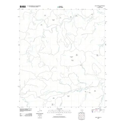
2010 Map of Love Creek
USGS Topo · Published 2010About this map
Tuff and the surrounding Hill Country terrain define this landscape at the confluence of the West Prong Medina River and several spring-fed tributaries. The geography is marked by a high density of named drainage features, including the North Prong Medina River and various deep-cut valleys such as Copperhead Hollow, Raven Roost Hollow, and Indian Hollow. Settlement patterns here are tied to long-standing ranching operations, with the Honey Creek Ranch and Rock Chimney Ranch anchoring the local topography alongside the Johnson Ranch Airport. Water sources are critical identifiers for this region, evidenced by the presence of Devils Bathtub Spring, Dripping Spring, and Main Spring. For those researching local family history, several burial sites are recorded on the map, including Adams Cemetery, Hillman Cemetery, and Honey Creek Cemetery, which are located near the primary transit routes of Ranch Rd 337 and Love Creek Rd.
Find a feature on this map
64 named features on this map. Tap any name to fly to it.
Don’t see what you’re looking for? This feature index may not catch every label — zoom into the map to look around manually.
Map Details
Editions of this 2010 Love Creek Map
This is the sole edition of this map. No revisions or reprints were ever made.
Other maps of this area

1954 · San Antonio
USGS Topo · 1:250,000

1956 · Tarpley
USGS Topo · 1:62,500

1956 · Tuff
USGS Topo · 1:62,500

1956 · Utopia
USGS Topo · 1:62,500

1957 · San Antonio
USGS Topo · 1:250,000

1964 · Sabinal Canyon
USGS Topo · 1:24,000

1964 · Well Hollow
USGS Topo · 1:24,000

1964 · Diamond S Ranch
USGS Topo · 1:24,000

1964 · Echo Hill Ranch
USGS Topo · 1:24,000
1964 · Love Creek
USGS Topo · 1:24,000