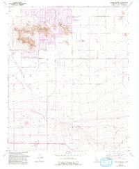
1957 Map of Lovejoy Buttes
USGS Topo · Published 1993About this map
Lake Los Angeles serves as the focal point of this high desert landscape, showcasing a planned community grid established north of the Lovejoy Buttes rock formations. The 1957 base survey, updated with 1990 data, reveals the intersection of residential expansion and critical water management in the Antelope Valley. Significant hydrological features include Big Rock Wash and Rock Creek, which are managed by a network of levees and check dams to control seasonal runoff. Further south, the settlement of Llano sits along the Pearblossom Highway, reflecting the corridor's role as a primary transportation artery. Local infrastructure is anchored by institutions like the Lake Los Angeles Sch and Vista San Gabriel Sch, alongside essential services like a Fire Sta and a Gaging Sta near the southern washes.
Find a feature on this map
27 named features on this map. Tap any name to fly to it.
Don’t see what you’re looking for? This feature index may not catch every label — zoom into the map to look around manually.
Map Details
Editions of this 1957 Lovejoy Buttes Map
4 editions found
Other maps of this area

1901 · Southern California Sheet No. 1
USGS Topo · 1:250,000

1903 · Rock Creek
USGS Topo · 1:62,500

1903 · San Antonio
USGS Topo · 1:62,500

1904 · Southern California Sheet No. 1
USGS Topo · 1:250,000

1930 · Lovejoy Springs
USGS Topo · 1:24,000

1930 · Black Butte
USGS Topo · 1:24,000

1930 · Llano
USGS Topo · 1:24,000

1930 · Wilsona
USGS Topo · 1:24,000

1933 · Lovejoy Springs
USGS Topo · 1:24,000

1933 · Black Butte
USGS Topo · 1:24,000