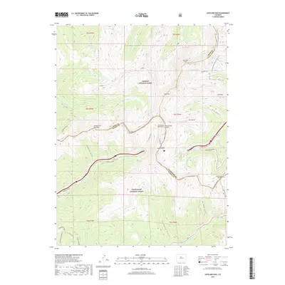
2019 Map of Loveland Pass
USGS Topo · Published 2019About this map
The Continental Divide bisects this high-elevation landscape, marking the hydrological split between the Arapaho National Forest and the White River National Forest. At the heart of the terrain is the engineered passage of the Eisenhower Memorial Tunnel, which carries interstate traffic beneath the ridge line of Coon Hill. This modern infrastructure contrasts with the surrounding alpine wilderness, where the Continental Divide National Scenic Trail winds past peaks like Mt Bethel and Pettingell Peak. To the east, the steep drainage of Herman Gulch and Dry Gulch flows toward the headwaters of Clear Creek, while the western slopes feed into Straight Creek and the Williams Fork Mountains. The map serves as a detailed record of the high-country travel routes, including the winding ascent of Loveland Pass Rd up to the Loveland Pass summit, passing by the quiet waters of Pass Lake.
Find a feature on this map
48 named features on this map. Tap any name to fly to it.
Don’t see what you’re looking for? This feature index may not catch every label — zoom into the map to look around manually.
Map Details
Editions of this 2019 Loveland Pass Map
This is the sole edition of this map. No revisions or reprints were ever made.
Other maps of this area

1924 · Montezuma
USGS Topo · 1:62,500

1924 · Fraser
USGS Topo · 1:62,500

1926 · Fraser
USGS Topo · 1:62,500

1926 · Montezuma
USGS Topo · 1:62,500

1929 · Dillon
USGS Topo · 1:62,500

1933 · Montezuma
USGS Topo · 1:62,500

1933 · Ute Peak
USGS Topo · 1:62,500

1934 · Dillon
USGS Topo · 1:62,500

1937 · Ute Peak
USGS Topo · 1:62,500

1953 · Denver
USGS Topo · 1:250,000