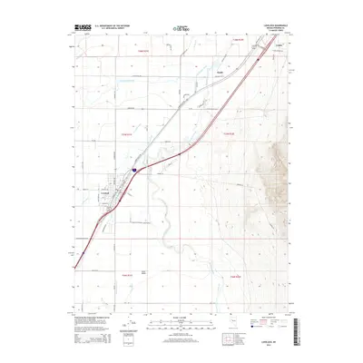
2014 Map of Lovelock
USGS Topo · Published 2014About this map
Lovelock serves as the focal point of this Pershing County landscape, where the Humboldt River and an intricate network of irrigation systems define the high desert terrain. The settlement pattern reflects a deep reliance on water management, evidenced by the numerous waterways such as the Old Channel Canal, Union Rodgers Canal, and Lovelock Drain that crisscross the Lower Valley. These engineered features support the agricultural life of the region, contrasting with the surrounding arid slopes. Historically significant routes like Old Emigrant Rd and the Lovelock Cave Back Country Bywy trace the paths of early travelers and lead toward local landmarks. Small transit-related sites like Kodak and Colado sit along the primary transportation corridors, while natural features like Willow Spring provide rare water sources in the more isolated sections of the quadrangle.
Find a feature on this map
53 named features on this map. Tap any name to fly to it.
Don’t see what you’re looking for? This feature index may not catch every label — zoom into the map to look around manually.
Map Details
Editions of this 2014 Lovelock Map
This is the sole edition of this map. No revisions or reprints were ever made.
Other maps of this area

1931 · Lovelock
USGS Topo · 1:250,000

1935 · Lovelock
USGS Topo · 1:250,000

1955 · Lovelock
USGS Topo · 1:250,000

1956 · Oreana
USGS Topo · 1:62,500

1956 · Toulon
USGS Topo · 1:62,500

1956 · Lovelock
USGS Topo · 1:62,500

1959 · Lovelock
USGS Topo · 1:250,000

1981 · Poker Brown Spring
USGS Topo · 1:24,000

1984 · Lovelock
USGS Topo · 1:100,000
1987 · Wildhorse Spring
USGS Topo · 1:24,000