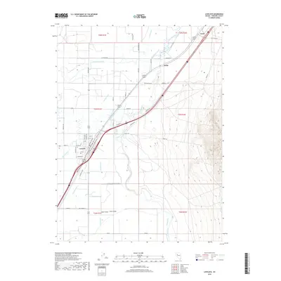
2018 Map of Lovelock
USGS Topo · Published 2018About this map
Lovelock serves as the central hub for this high-desert agricultural landscape, where the Humboldt River supports an intricate network of irrigation infrastructure. The map reveals the critical importance of water management in Pershing County, tracing the paths of the Union Rodgers Canal, American Canal, and Lovelock Drain. This 2018 survey illustrates how modern development follows historic lines, with paths like Wagontrain Rd and Old Emigrant Rd echoing the region's role as a major westward passage. Small rail-side locations like Kodak and Colado sit northeast of town along the transport corridor, while the Upper Valley and Lower Valley highlight the local transition from town center to outlying farm tracts. The grid of roads, such as Holmstrom Rd and Kruse Rd, defines the cultivated fields that sustain the community.
Find a feature on this map
62 named features on this map. Tap any name to fly to it.
Don’t see what you’re looking for? This feature index may not catch every label — zoom into the map to look around manually.
Map Details
Editions of this 2018 Lovelock Map
This is the sole edition of this map. No revisions or reprints were ever made.
Other maps of this area

1931 · Lovelock
USGS Topo · 1:250,000

1935 · Lovelock
USGS Topo · 1:250,000

1955 · Lovelock
USGS Topo · 1:250,000

1956 · Oreana
USGS Topo · 1:62,500

1956 · Toulon
USGS Topo · 1:62,500

1956 · Lovelock
USGS Topo · 1:62,500

1959 · Lovelock
USGS Topo · 1:250,000

1981 · Poker Brown Spring
USGS Topo · 1:24,000

1984 · Lovelock
USGS Topo · 1:100,000
1987 · Wildhorse Spring
USGS Topo · 1:24,000