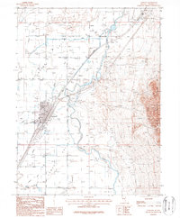
1987 Map of Lovelock
USGS Topo · Published 1988About this map
Lovelock serves as the hub of this Nevada landscape, where the Humboldt River and its intricate network of irrigation canals sustain the Upper Valley and Lower Valley. The map details the complex water management systems essential to high-desert life, including the Rodgers Dam, Irish-American Dam, and the persistent paths of the Old Channel and Young Ditch. Industrial and agricultural infrastructure is evident in the presence of Southern Pacific and Union Pacific rail lines that flank the river corridor.
Find a feature on this map
36 named features on this map. Tap any name to fly to it.
Don’t see what you’re looking for? This feature index may not catch every label — zoom into the map to look around manually.
Map Details
Editions of this 1987 Lovelock Map
This is the sole edition of this map. No revisions or reprints were ever made.
Other maps of this area

1931 · Lovelock
USGS Topo · 1:250,000

1935 · Lovelock
USGS Topo · 1:250,000

1955 · Lovelock
USGS Topo · 1:250,000

1956 · Oreana
USGS Topo · 1:62,500

1956 · Toulon
USGS Topo · 1:62,500

1956 · Lovelock
USGS Topo · 1:62,500

1959 · Lovelock
USGS Topo · 1:250,000

1981 · Poker Brown Spring
USGS Topo · 1:24,000

1984 · Lovelock
USGS Topo · 1:100,000
1987 · Wildhorse Spring
USGS Topo · 1:24,000