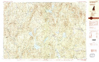
1984 Map of Lovewell Mountain
USGS Topo · Published 1984About this map
Pillsbury State Park and the high ridges of Lovewell Mountain dominate this landscape on the border of Sullivan, Cheshire, and Merrimack counties. The terrain is characterized by a high density of small ponds and wetlands, including Ashuelot Pond, Millen Lake, and Sand Pond, which feed the headwaters of the Ashuelot River. Settlement is concentrated in small upland villages such as Washington, East Washington, and East Lempster, where the road network connects scattered farmsteads and rural homes. The presence of Gee Mill and Shedd suggests a history of localized industry tied to the region's timber and water resources.
Find a feature on this map
98 named features on this map. Tap any name to fly to it.
Don’t see what you’re looking for? This feature index may not catch every label — zoom into the map to look around manually.
Map Details
Editions of this 1984 Lovewell Mountain Map
3 editions found
Other maps of this area

1902 · Sunapee
USGS Topo · 1:62,500

1905 · Sunapee
USGS Topo · 1:62,500

1907 · Sunapee
USGS Topo · 1:62,500

1926 · Hillsboro
USGS Topo · 1:62,500

1926 · Claremont
USGS Topo · 1:62,500

1927 · Bellows Falls
USGS Topo · 1:48,000

1928 · Mount Kearsarge
USGS Topo · 1:62,500

1929 · Claremont
USGS Topo · 1:62,500

1929 · Hillsboro
USGS Topo · 1:62,500

1930 · Lovewell Mountain
USGS Topo · 1:62,500