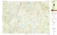
1984 Map of Lovewell Mountain
USGS Topo · Published 1984About this map
Pillsbury State Park dominates the high ground of the Sunapee Ridge, where the headwaters of the Ashuelot River begin their descent through a landscape of glacial ponds and granite heights. This mid-1980s survey captures the rural character of the Sullivan County highlands, centered on the historic town of Washington and its outlying neighbor East Washington. The map reveals a settlement pattern defined by small mill sites and crossroads like Gee Mill and Marlow Junction, connected by winding routes such as Woodward Road. Massive conservation tracts, including Dodge Brook State Forest and Honey Brook State Forest, preserve the rugged wooded character of the terrain surrounding Lovewell Mountain. Genealogists will find interest in the scattered residential markers near Dodge Hollow and Shedd, showing the persistent footprint of mountain farming and early timber industry in this corner of New Hampshire.
Find a feature on this map
105 named features on this map. Tap any name to fly to it.
Don’t see what you’re looking for? This feature index may not catch every label — zoom into the map to look around manually.
Map Details
Editions of this 1984 Lovewell Mountain Map
3 editions found
Other maps of this area

1902 · Sunapee
USGS Topo · 1:62,500

1905 · Sunapee
USGS Topo · 1:62,500

1907 · Sunapee
USGS Topo · 1:62,500

1926 · Hillsboro
USGS Topo · 1:62,500

1926 · Claremont
USGS Topo · 1:62,500

1927 · Bellows Falls
USGS Topo · 1:48,000

1928 · Mount Kearsarge
USGS Topo · 1:62,500

1929 · Claremont
USGS Topo · 1:62,500

1929 · Hillsboro
USGS Topo · 1:62,500

1930 · Lovewell Mountain
USGS Topo · 1:62,500