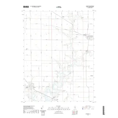
2021 Map of Lovington
USGS Topo · Published 2021About this map
Lovington and Bethany anchor this portion of Moultrie County, separated by the winding path of the W Okaw River. The landscape is a study in Illinois prairie geography, where the rigid township-and-range grid of gravel roads like Co RD 600 E and Co RD 700 E intersects with the natural meandering of Jonathan Br and Stringtown Br. This modern survey documents the persistent agricultural identity of the region, punctuated by several small settlements like Cushman, Dunn, and Ullrich. Genealogists will find significant value in the distribution of family and community burial grounds, ranging from the Marrowbone Township Cem near Bethany to the more secluded Pea Cem and Keller Cem. The map provides a clear look at the local infrastructure including Co HWY 1 and Old Springfield road, which continue to serve as vital connectors for these farming communities.
Find a feature on this map
70 named features on this map. Tap any name to fly to it.
Don’t see what you’re looking for? This feature index may not catch every label — zoom into the map to look around manually.
Map Details
Editions of this 2021 Lovington Map
This is the sole edition of this map. No revisions or reprints were ever made.
Other maps of this area

1929 · Decatur
USGS Topo · 1:62,500

1933 · Decatur
USGS Topo · 1:62,500

1935 · Sullivan
USGS Topo · 1:48,000

1940 · Sullivan
USGS Topo · 1:62,500

1949 · Dalton City
USGS Topo · 1:62,500

1955 · Bement
USGS Topo · 1:62,500

1958 · Decatur
USGS Topo · 1:250,000

1961 · Decatur
USGS Topo · 1:250,000

1967 · Long Creek
USGS Topo · 1:24,000
1975 · Bement SE
USGS Topo · 1:24,000