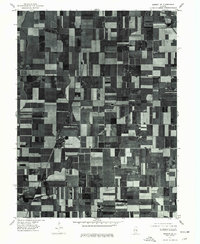
1975 Map of Bement SE
USGS Topo · Published 1977About this map
Hammond anchors the southwestern corner of this 1975 orthophotoquad, showing the intricate patchwork of central Illinois farmland at the height of the mid-1970s. This aerial perspective, captured by the U. S. Geological Survey, reveals the geometric precision of the township-and-range system, where fields are dissected by straight section-line roads. Small clusters of development at Pierson and Hammond represent the rural hubs of the era, while the drainages of Lake and Fork break the otherwise rigid agricultural grid. These orthophotoquads are particularly valuable for researchers because they provide a literal photographic record of vegetation, farmstead layouts, and drainage patterns that standard topographic symbols often generalize, offering a direct view of the Piatt County landscape as it existed decades ago.
Find a feature on this map
4 named features on this map. Tap any name to fly to it.
Don’t see what you’re looking for? This feature index may not catch every label — zoom into the map to look around manually.
Map Details
Editions of this 1975 Bement SE Map
This is the sole edition of this map. No revisions or reprints were ever made.
Other maps of this area

1935 · Arcola
USGS Topo · 1:48,000

1935 · Sullivan
USGS Topo · 1:48,000

1940 · Sullivan
USGS Topo · 1:62,500

1940 · Arcola
USGS Topo · 1:62,500

1950 · Tuscola
USGS Topo · 1:62,500

1955 · Bement
USGS Topo · 1:62,500

1958 · Decatur
USGS Topo · 1:250,000

1961 · Decatur
USGS Topo · 1:250,000
1975 · Tuscola NW
USGS Topo · 1:24,000
1975 · Tuscola SW
USGS Topo · 1:24,000