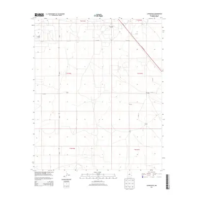
2013 Map of Lovington SE
USGS Topo · Published 2013About this map
The West Lovington Oil Field and East Lovington Oil Field anchor this high plains landscape in the Permian Basin, illustrating the intersection of energy extraction and ranching in Lea County. The terrain is marked by the expansive holdings of several family operations, including the Turner Ranch, Kimbrough Ranch, and Culp Ranch. These rural properties are supported by vital water sources such as Adobe Well and Eller Well, which are essential for sustaining livestock in this arid environment.
Find a feature on this map
23 named features on this map. Tap any name to fly to it.
Don’t see what you’re looking for? This feature index may not catch every label — zoom into the map to look around manually.
Map Details
Editions of this 2013 Lovington SE Map
This is the sole edition of this map. No revisions or reprints were ever made.
Other maps of this area

1954 · Hobbs
USGS Topo · 1:250,000

1958 · Hobbs
USGS Topo · 1:250,000

1962 · Lovington
USGS Topo · 1:24,000

1962 · Lovington
USGS Topo · 1:62,500

1963 · Monument
USGS Topo · 1:62,500

1969 · Humble City
USGS Topo · 1:24,000

1969 · Hobbs West
USGS Topo · 1:24,000
1985 · Monument North
USGS Topo · 1:24,000
1985 · Lovington NW
USGS Topo · 1:24,000
1985 · Lovington SE
USGS Topo · 1:24,000