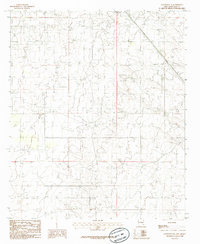
1985 Map of Lovington SE
USGS Topo · Published 1985About this map
The High Plains of the Llano Estacado define this industrial landscape in southeastern New Mexico during the mid-1980s. A widespread Oil Field dominates the terrain, marked by a dense network of extraction infrastructure and service roads that speak to the region's primary economic driver. Evidence of local construction and infrastructure maintenance is visible in the presence of a Gravel Pit located in the western portion of the survey. The map depicts a period of significant petroleum activity, where the natural topography is secondary to the systematic grid of energy development. This 1985 survey, produced from field checks in 1979, provides an essential record of the resource extraction footprint in Lea County before later technological shifts in the basin.
Find a feature on this map
5 named features on this map. Tap any name to fly to it.
Don’t see what you’re looking for? This feature index may not catch every label — zoom into the map to look around manually.
Map Details
Editions of this 1985 Lovington SE Map
This is the sole edition of this map. No revisions or reprints were ever made.
Other maps of this area

1954 · Hobbs
USGS Topo · 1:250,000

1958 · Hobbs
USGS Topo · 1:250,000

1962 · Lovington
USGS Topo · 1:24,000

1962 · Lovington
USGS Topo · 1:62,500

1963 · Monument
USGS Topo · 1:62,500

1969 · Humble City
USGS Topo · 1:24,000

1969 · Hobbs West
USGS Topo · 1:24,000
1985 · Monument North
USGS Topo · 1:24,000
1985 · Lovington NW
USGS Topo · 1:24,000
1985 · Lovington SW
USGS Topo · 1:24,000