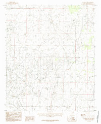
1985 Map of Lovington SW
USGS Topo · Published 1985About this map
The arid landscape of Lea County in the mid-1980s is defined by industrial extraction and water management. This provisional survey captures the open expanse south of Lovington, where the infrastructure of an unnamed Field dominates the high plains terrain. The presence of a Gravel Pit indicates local mining activity, while several stretches of Aqueduct suggest the critical importance of water transport in this semi-arid region. Unlike more densely populated areas, this portion of New Mexico is characterized by its organized grid of section lines and range boundaries, specifically near the junction of Range 35 East and Range 36 East. The map provides a focused view of the engineering required to sustain industry and resource development in the Llano Estacado during this era of growth.
Find a feature on this map
6 named features on this map. Tap any name to fly to it.
Don’t see what you’re looking for? This feature index may not catch every label — zoom into the map to look around manually.
Map Details
Editions of this 1985 Lovington SW Map
This is the sole edition of this map. No revisions or reprints were ever made.
Other maps of this area

1954 · Hobbs
USGS Topo · 1:250,000

1958 · Hobbs
USGS Topo · 1:250,000

1962 · Lovington
USGS Topo · 1:24,000

1962 · Lovington
USGS Topo · 1:62,500

1962 · Buckeye
USGS Topo · 1:62,500

1963 · Monument
USGS Topo · 1:62,500

1963 · Laguna Gatuna
USGS Topo · 1:62,500

1984 · Ironhouse Well
USGS Topo · 1:24,000
1985 · Monument North
USGS Topo · 1:24,000
1985 · Lovington NW
USGS Topo · 1:24,000