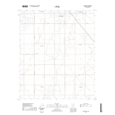
2020 Map of Lovington SE
USGS Topo · Published 2020About this map
Lovington serves as the primary anchor for this landscape in the Llano Estacado region, where the street grid of the city's southeast quadrant transitions into a vast expanse of section lines and range boundaries. The area is defined by its rectilinear land management, with major routes like Arkansas Junction and Co Rd 78 carving out the high plains. Local geography is further detailed through a network of rural roads such as W Stiles Rd, Buckeye Rd, and U-Bar Rd, which likely reflect the ranching and energy-sector history of Lea County. The map provides a clear look at the intersection of municipal development and the broader survey system, tracing the boundaries between T16S, T17S, and T18S.
Find a feature on this map
16 named features on this map. Tap any name to fly to it.
Don’t see what you’re looking for? This feature index may not catch every label — zoom into the map to look around manually.
Map Details
Editions of this 2020 Lovington SE Map
This is the sole edition of this map. No revisions or reprints were ever made.
Other maps of this area

1954 · Hobbs
USGS Topo · 1:250,000

1958 · Hobbs
USGS Topo · 1:250,000

1962 · Lovington
USGS Topo · 1:24,000

1962 · Lovington
USGS Topo · 1:62,500

1963 · Monument
USGS Topo · 1:62,500

1969 · Humble City
USGS Topo · 1:24,000

1969 · Hobbs West
USGS Topo · 1:24,000
1985 · Monument North
USGS Topo · 1:24,000
1985 · Lovington NW
USGS Topo · 1:24,000
1985 · Lovington SE
USGS Topo · 1:24,000