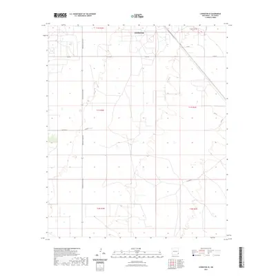
2023 Map of Lovington SE
USGS Topo · Published 2023About this map
The southeastern outskirts of Lovington dominate the northern portion of this High Plains landscape, where the orderly grid of the Public Land Survey System meets the expanding infrastructure of Lea County. A primary corridor is defined by Arkansas Junction, which serves as a central north-south axis through the quadrangle. The map reveals a transition from the structured residential and industrial streets near the town center, such as Kyle St and W Alabama St, to the wide-reaching ranch and service roads that crisscross the arid terrain. Notable among these are Buckeye Rd, W Stiles Rd, and U-Bar Rd, reflecting the regional reliance on a robust road network to connect remote production sites and homesteads. The survey also captures smaller thoroughfares like Goff Pl, illustrating the localized development pattern south of the main settlement.
Find a feature on this map
16 named features on this map. Tap any name to fly to it.
Don’t see what you’re looking for? This feature index may not catch every label — zoom into the map to look around manually.
Map Details
Editions of this 2023 Lovington SE Map
This is the sole edition of this map. No revisions or reprints were ever made.
Other maps of this area

1954 · Hobbs
USGS Topo · 1:250,000

1958 · Hobbs
USGS Topo · 1:250,000

1962 · Lovington
USGS Topo · 1:24,000

1962 · Lovington
USGS Topo · 1:62,500

1963 · Monument
USGS Topo · 1:62,500

1969 · Humble City
USGS Topo · 1:24,000

1969 · Hobbs West
USGS Topo · 1:24,000
1985 · Monument North
USGS Topo · 1:24,000
1985 · Lovington NW
USGS Topo · 1:24,000
1985 · Lovington SE
USGS Topo · 1:24,000