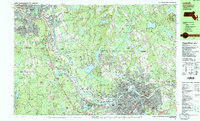
1987 Map of Lowell
USGS Topo · Published 1987About this map
The Merrimack River snakes through this landscape, serving as the historical spine for the industrial development of Lowell and surrounding townships like Tyngsborough and Dracut. By the late 1980s, the urban density of the Highlands and Belvidere neighborhoods contrasts with the preserved woodlands of the Lowell Dracut State Forest. Genealogists will find a wealth of burial grounds, including the large St Marys Cem and the smaller Gibson Cem. The map documents a complex educational and religious infrastructure, featuring the Academy of Notre Dame, St Josephs Ch, and St Anthonys Friary. Industrial and transport legacies are visible through the Boston and Maine railroad lines and the development of the Lowell Heritage State Park, which repurposes the city's historic canal-side environment for public use.
Find a feature on this map
106 named features on this map. Tap any name to fly to it.
Don’t see what you’re looking for? This feature index may not catch every label — zoom into the map to look around manually.
Map Details
Editions of this 1987 Lowell Map
2 editions found
Other maps of this area

1886 · Lawrence
USGS Topo · 1:62,500

1886 · Lowell
USGS Topo · 1:62,500

1888 · Haverhill
USGS Topo · 1:62,500

1888 · Lawrence
USGS Topo · 1:62,500

1890 · Haverhill
USGS Topo · 1:62,500

1893 · Lowell
USGS Topo · 1:62,500

1893 · Lawrence
USGS Topo · 1:62,500

1893 · Haverhill
USGS Topo · 1:62,500

1893 · Groton
USGS Topo · 1:62,500

1905 · Manchester
USGS Topo · 1:62,500