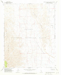
1969 Map of Lower Pahranagat Lake SE
USGS Topo · Published 1973About this map
Desert National Wildlife Range dominates this landscape in southern Lincoln County, as documented by field checks in 1969. The topography is defined by the steep verticality of the Sheep Range, which gives way to the broad, arid expanse of Coyote Spring Valley in the southeast. This survey captures a moment in the mid-20th century before significant modern infrastructure altered the drainage patterns of Pahranagat Wash. The absence of roads or trails throughout the entire quadrangle emphasizes the area's primary role as a protected habitat and geological corridor. Precise survey lines for T. 10 S. and T. 11 S. grid the map, providing a structural framework for a terrain that remained largely undeveloped and dedicated to wildlife conservation during this era.
Find a feature on this map
7 named features on this map. Tap any name to fly to it.
Don’t see what you’re looking for? This feature index may not catch every label — zoom into the map to look around manually.
Map Details
Editions of this 1969 Lower Pahranagat Lake SE Map
This is the sole edition of this map. No revisions or reprints were ever made.
Other maps of this area

1885 · Pioche
USGS Topo · 1:250,000

1886 · Saint Thomas
USGS Topo · 1:250,000

1886 · Pioche
USGS Topo · 1:250,000

1893 · Saint Thomas
USGS Topo · 1:250,000

1907 · Las Vegas
USGS Topo · 1:250,000

1908 · Las Vegas
USGS Topo · 1:250,000

1945 · Sheep Range
USGS Topo · 1:125,000

1945 · Alamo
USGS Topo · 1:125,000

1954 · Caliente
USGS Topo · 1:250,000

1954 · Las Vegas
USGS Topo · 1:250,000