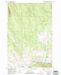
1962 Map of Lower Seymour Lake
USGS Topo · Published 1994About this map
Deerlodge National Forest and Beaverhead National Forest meet in this high-altitude landscape, where the Anaconda Pintler Wilderness provides a backdrop for a series of drainage networks. The water system is dominated by the Big Hole River flowing along the southern boundary, fed by numerous tributaries including Seymour Creek, Chub Creek, and La Marche Creek. Near the center of the sheet, Lower Seymour Lake is accessible via a Pack Trail, representing the remote character of the region before more modern infrastructure expanded.
Find a feature on this map
26 named features on this map. Tap any name to fly to it.
Don’t see what you’re looking for? This feature index may not catch every label — zoom into the map to look around manually.
Map Details
Editions of this 1962 Lower Seymour Lake Map
3 editions found

Other maps of this area

1908 · Philipsburg
USGS Topo · 1:125,000

1947 · Butte
USGS Topo · 1:250,000

1955 · Dillon
USGS Topo · 1:250,000

1957 · Dillon
USGS Topo · 1:250,000

1958 · Butte
USGS Topo · 1:250,000

1958 · Dillon
USGS Topo · 1:250,000

1960 · Butte
USGS Topo · 1:250,000

1962 · Butte
USGS Topo · 1:250,000

1962 · Dillon
USGS Topo · 1:250,000

1962 · Lincoln Gulch
USGS Topo · 1:24,000