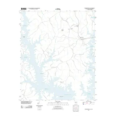
2011 Map of Lowndesville
USGS Topo · Published 2011About this map
Lowndesville serves as the focal point of this South Carolina landscape, positioned just east of the expansive waters of Richard B Russell Lake. The terrain is defined by the intricate dendritic drainage of Deal Creek, Bond Creek, and Charlies Creek, which feed into the larger reservoir. For genealogists, the map is particularly detailed regarding burial sites, noting Smyrna Cemetery, Providence Cemetery, and the Old McCalla Cemetery near the shores of McCalla Island. The 2011 survey also highlights infrastructure like the Lowndesville Post Office and water management features such as the Paradise Valley Lake Dam D-3029. This area represents a transition from traditional agricultural land use to a landscape dominated by the Corps of Engineers' reservoir, where historical river features like Gregg Shoals now sit adjacent to the modern shoreline.
Find a feature on this map
65 named features on this map. Tap any name to fly to it.
Don’t see what you’re looking for? This feature index may not catch every label — zoom into the map to look around manually.
Map Details
Editions of this 2011 Lowndesville Map
This is the sole edition of this map. No revisions or reprints were ever made.
Other maps of this area

1893 · Elberton
USGS Topo · 1:125,000

1954 · Greenville
USGS Topo · 1:250,000

1958 · Greenville
USGS Topo · 1:250,000

1958 · Elberton
USGS Topo · 1:62,500

1959 · Hartwell Dam
USGS Topo · 1:24,000

1964 · Iva
USGS Topo · 1:24,000

1964 · Antreville
USGS Topo · 1:24,000

1964 · Lowndesville
USGS Topo · 1:24,000
1964 · Calhoun Falls
USGS Topo · 1:24,000
1964 · Latimer
USGS Topo · 1:24,000