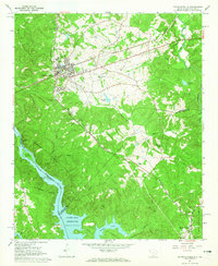
1964 Map of Calhoun Falls
USGS Topo · Published 1965About this map
Calhoun Falls serves as the primary hub of this 1964 survey, situated at the junction of the Seaboard Air Line and the Atlantic Coast Line railroads. The landscape is defined by the expansive waters of the Clark Hill Reservoir along the Savannah River, where the US Reservation boundary follows the normal pool elevation of 330 feet.
Find a feature on this map
49 named features on this map. Tap any name to fly to it.
Don’t see what you’re looking for? This feature index may not catch every label — zoom into the map to look around manually.
Map Details
Editions of this 1964 Calhoun Falls Map
3 editions found
Other maps of this area

1892 · Mc Cormick
USGS Topo · 1:125,000

1892 · Abbeville
USGS Topo · 1:125,000

1893 · Elberton
USGS Topo · 1:125,000

1906 · Crawfordville
USGS Topo · 1:125,000

1912 · Mc Cormick
USGS Topo · 1:125,000

1948 · Abbeville West
USGS Topo · 1:24,000

1949 · Abbeville
USGS Topo · 1:24,000

1949 · Calhoun Creek
USGS Topo · 1:24,000

1953 · Athens
USGS Topo · 1:250,000

1954 · Greenville
USGS Topo · 1:250,000