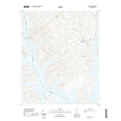
2020 Map of Lowndesville
USGS Topo · Published 2020About this map
Lowndesville serves as the primary upland settlement in this portion of Abbeville County, situated just east of the expansive waters of Richard B Russell Lake. The landscape is defined by the intricate dendritic drainage of several significant watercourses, including Charlies Cr, Crooked Cr, and Allen Cr, which feed into the Savannah River basin. This 2020 survey illustrates the contemporary interface between the rural South Carolina landscape and the artificial shoreline created by the lake's impoundment.
Find a feature on this map
61 named features on this map. Tap any name to fly to it.
Don’t see what you’re looking for? This feature index may not catch every label — zoom into the map to look around manually.
Map Details
Editions of this 2020 Lowndesville Map
This is the sole edition of this map. No revisions or reprints were ever made.
Other maps of this area

1893 · Elberton
USGS Topo · 1:125,000

1954 · Greenville
USGS Topo · 1:250,000

1958 · Greenville
USGS Topo · 1:250,000

1958 · Elberton
USGS Topo · 1:62,500

1959 · Hartwell Dam
USGS Topo · 1:24,000

1964 · Iva
USGS Topo · 1:24,000

1964 · Antreville
USGS Topo · 1:24,000

1964 · Lowndesville
USGS Topo · 1:24,000
1964 · Calhoun Falls
USGS Topo · 1:24,000
1964 · Latimer
USGS Topo · 1:24,000