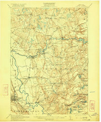
1913 Map of Lowville
USGS Topo · Published 1921About this map
Lowville and the Beaver River valley serve as the primary anchors of this Lewis County survey, which details a landscape transitioning from industrialized river towns to the pond-strewn highlands of the Adirondack fringe. The Lowville and Beaver River railroad line follows the water, connecting settlements like Beaver Falls and Croghan, where the river's descent is utilized by a Power Plant at Elmer Falls. This era of development is defined by a dense network of local schoolhouses, including the Texas Road School, Monnatt School, and Puffer School, reflecting a settled rural population before the mid-century consolidation of districts. To the east, the terrain becomes more varied as the elevation rises toward Beech Hill. Here, the map documents a cluster of recreation and industry near Crystal Lake, with sites like Petries Mill and numerous family-named landmarks such as Bushes Landing and Petries Corners providing valuable points of reference for local historians.
Find a feature on this map
81 named features on this map. Tap any name to fly to it.
Don’t see what you’re looking for? This feature index may not catch every label — zoom into the map to look around manually.
Map Details
Editions of this 1913 Lowville Map
5 editions found
Other maps of this area

1902 · Carthage
USGS Topo · 1:62,500

1904 · Carthage
USGS Topo · 1:62,500

1905 · Port Leyden
USGS Topo · 1:62,500

1906 · Highmarket
USGS Topo · 1:62,500

1907 · Port Leyden
USGS Topo · 1:62,500

1911 · Antwerp
USGS Topo · 1:62,500

1911 · Lowville
USGS Topo · 1:62,500

1912 · Number Four
USGS Topo · 1:62,500

1912 · Mc Keever
USGS Topo · 1:62,500

1913 · Lowville
USGS Topo · 1:62,500