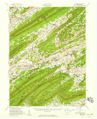
1952 Map of Loysville
USGS Topo · Published 1959About this map
Tuscarora Mountain and Sherman Mountain dominate this landscape, carving a series of narrow valleys defined by parallel ridges like Limestone Ridge and Mahanoy Ridge. In the central valley, the settlement of Loysville serves as a local hub near Fort Robertson, surrounded by a dense network of nineteenth-century infrastructure including the Old R.R. Grade and numerous country schools such as Freedom Sch and Pine Hill Sch. The area's genealogical depth is visible in the many rural burial grounds, from the St Paul Cem near Andersonburg to the Eshcol Memorial Cem in the north. The presence of several pumping stations and a Sub Sta indicates the modernization of utility corridors through Sheaffer Valley and Lower Mifflin, while traditional community centers like Mt Zion Ch and Wesley Chapel remain as local anchors.
Find a feature on this map
142 named features on this map. Tap any name to fly to it.
Don’t see what you’re looking for? This feature index may not catch every label — zoom into the map to look around manually.
Map Details
Editions of this 1952 Loysville Map
2 editions found
Other maps of this area

1904 · Carlisle
USGS Topo · 1:62,500

1907 · New Bloomfield
USGS Topo · 1:62,500

1907 · Millerstown
USGS Topo · 1:62,500

1919 · Newville
USGS Topo · 1:62,500

1919 · Mattawana
USGS Topo · 1:62,500

1923 · Shippensburg
USGS Topo · 1:62,500

1924 · Lewistown
USGS Topo · 1:62,500

1925 · Mifflintown
USGS Topo · 1:48,000

1927 · Lewisburg
USGS Topo · 1:62,500

1930 · Loysville
USGS Topo · 1:62,500
Featured Places
- Saville Township, PA
- Centre, Southwest Madison Township
- Spruce Hill Township, PA
- Landisburg, PA
- Milford Township, PA