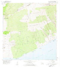
1957 Map of Lualailua Hills
USGS Topo · Published 1974About this map
Haleakala National Park defines the northern reaches of this landscape, where the Haleakala Crater and peaks like Haupaakea Pk look down toward the southern coast of Maui. The terrain is characterized by a series of deep gulches, including Manawainui Gulch and Kepuni Gulch, which carve through the Kahikinui Forest Reserve and Makawao Forest Reserve. Scattered settlements and landmarks such as Kahikinui House, Hokukano, and Waiopai are connected by the coastal Piilani Highway and various interior jeep trails. The coastline features the Pakowai Natural Arch and prominent points like Nakaohu Pt. This 1957 field survey captures the transition from high-elevation volcanic peaks and forest reserves down to the remote coastal ranching and maritime areas of the Makawao and Hana Districts.
Find a feature on this map
48 named features on this map. Tap any name to fly to it.
Don’t see what you’re looking for? This feature index may not catch every label — zoom into the map to look around manually.
Map Details
Editions of this 1957 Lualailua Hills Map
2 editions found
Other maps of this area

1954 · Maui
USGS Topo · 1:250,000

1954 · Puu O Kali
USGS Topo · 1:24,000

1954 · Makena
USGS Topo · 1:24,000

1957 · Kilohana
USGS Topo · 1:24,000

1957 · Lualailua Hills
USGS Topo · 1:24,000

1957 · Nahiku
USGS Topo · 1:24,000

1957 · Kaupo
USGS Topo · 1:24,000

1966 · Maui
USGS Topo · 1:250,000

1974 · Maui
USGS Topo · 1:250,000
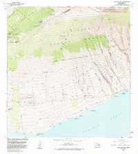
1983 · Lualailua Hills
USGS Topo · 1:24,000