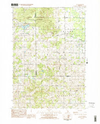
1983 Map of Lucas
USGS Topo · Published 1984About this map
Pere Marquette State Forest occupies the northwestern corner of this territory, where the borders of Wexford, Missaukee, and Osceola counties meet. The landscape is defined by a transition from the wooded state forest to the organized agricultural townships of Richland, Highland, and Sherman. The village of Lucas serves as a central hub, connected to the wider region by the Michigan Northern railroad line. Local social infrastructure is well-represented through the Lucas-McBain Sch, South Community Ch, and the rural Richland Cem. Water features such as Berry Lake and Slick Cr provide the primary drainage for these upland plateaus, while a network of rural routes like Finkle Road and Geers Rd link the surrounding farmsteads and the community of Falmouth.
Find a feature on this map
30 named features on this map. Tap any name to fly to it.
Don’t see what you’re looking for? This feature index may not catch every label — zoom into the map to look around manually.
Map Details
Editions of this 1983 Lucas Map
2 editions found
Other maps of this area

1954 · Traverse City
USGS Topo · 1:250,000

1956 · Cadillac North
USGS Topo · 1:62,500

1956 · Lake City
USGS Topo · 1:62,500

1957 · Cadillac South
USGS Topo · 1:62,500

1957 · Marion
USGS Topo · 1:62,500

1958 · Traverse City
USGS Topo · 1:250,000
1983 · Dighton
USGS Topo · 1:25,000

1983 · Cadillac
USGS Topo · 1:100,000
1983 · Le Roy
USGS Topo · 1:25,000

1983 · Lake City
USGS Topo · 1:25,000