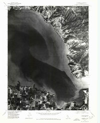
1977 Map of Lucerne
USGS Topo · Published 1980About this map
Clear Lake dominates this 1977 orthophotoquad, revealing the intricate texture of the California shoreline and the surrounding topography during the late 1970s. The settlement of Lucerne sits along the northeastern edge of the water, its residential grid clearly visible against the rising terrain, while the community of Nice occupies the northern bend. This aerial perspective, prepared from June 1977 photography, provides an unusually clear look at the agricultural patterns south of the lake, where the delta of Kelsey Creek feeds into the basin. The contrast between the organized vineyard or orchard plots on the southern flats and the rugged, undeveloped hillsides above the lakeside towns illustrates the distinct geographic constraints that shaped local development around the lake's edge.
Find a feature on this map
4 named features on this map. Tap any name to fly to it.
Don’t see what you’re looking for? This feature index may not catch every label — zoom into the map to look around manually.
Map Details
Editions of this 1977 Lucerne Map
This is the sole edition of this map. No revisions or reprints were ever made.
Other maps of this area

1921 · Kelseyville
USGS Topo · 1:62,500

1924 · Bartlett Springs
USGS Topo · 1:62,500

1938 · Lakeport
USGS Topo · 1:62,500

1942 · Bartlett Springs
USGS Topo · 1:62,500

1943 · Kelseyville
USGS Topo · 1:62,500

1944 · Bartlett Springs
USGS Topo · 1:62,500

1945 · Lower Lake
USGS Topo · 1:62,500

1947 · Santa Rosa
USGS Topo · 1:250,000

1949 · Santa Rosa
USGS Topo · 1:250,000

1951 · Lakeport
USGS Topo · 1:62,500