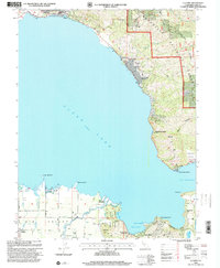
1996 Map of Lucerne
USGS Topo · Published 2001About this map
Clear Lake dominates this mid-1990s landscape, its eastern and western shores defined by a mix of established resort communities and agricultural land. The northern shore is anchored by the towns of Lucerne and Nice, while the southern reaches reveal the transition from the fruit-growing flats of Big Valley to the volcanic topography surrounding Soda Bay. This era shows a well-developed shoreline including Laurel Beach and Pepperwood Grove, alongside recreation-focused sites like the Ferndale Resort Seaplane Base.
Find a feature on this map
56 named features on this map. Tap any name to fly to it.
Don’t see what you’re looking for? This feature index may not catch every label — zoom into the map to look around manually.
Map Details
Editions of this 1996 Lucerne Map
This is the sole edition of this map. No revisions or reprints were ever made.
Other maps of this area

1921 · Kelseyville
USGS Topo · 1:62,500

1924 · Bartlett Springs
USGS Topo · 1:62,500

1938 · Lakeport
USGS Topo · 1:62,500

1942 · Bartlett Springs
USGS Topo · 1:62,500

1943 · Kelseyville
USGS Topo · 1:62,500

1944 · Bartlett Springs
USGS Topo · 1:62,500

1945 · Lower Lake
USGS Topo · 1:62,500

1947 · Santa Rosa
USGS Topo · 1:250,000

1949 · Santa Rosa
USGS Topo · 1:250,000

1951 · Lakeport
USGS Topo · 1:62,500