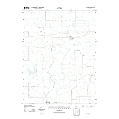
2012 Map of Lucerne
USGS Topo · Published 2012About this map
Newtown and Lucerne anchor this northern Missouri landscape, where a dense network of county roads connects rural farmsteads across a terrain defined by the winding course of Medicine Creek. This area of Sullivan County maintains its early 20th-century agricultural layout, with many roads still following the township and range lines established decades earlier. Genealogists will find significant local history at the Busby Cemetery and the nearby Old Busby Cemetery, providing a window into the generational roots of the families who settled near Barber Creek and Long Branch. The drainage pattern is particularly intricate here, as the land falls south through numerous tributaries like Hooton Creek, Lick Branch, and Little West Locust Creek, which helped dictate the original placement of small settlements and river crossings.
Find a feature on this map
41 named features on this map. Tap any name to fly to it.
Don’t see what you’re looking for? This feature index may not catch every label — zoom into the map to look around manually.
Map Details
Editions of this 2012 Lucerne Map
This is the sole edition of this map. No revisions or reprints were ever made.
Other maps of this area

1942 · Seymour
USGS Topo · 1:62,500

1944 · Seymour
USGS Topo · 1:62,500

1954 · Centerville
USGS Topo · 1:250,000

1957 · Centerville
USGS Topo · 1:250,000

1958 · Centerville
USGS Topo · 1:250,000

1964 · Pollock NW
USGS Topo · 1:24,000

1964 · Ravanna
USGS Topo · 1:24,000

1964 · Harris
USGS Topo · 1:24,000

1964 · Half Rock
USGS Topo · 1:24,000
1964 · Pollock SW
USGS Topo · 1:24,000